

Dutch treat?
Source:Economynext
PAST
Colombo is a wetland in case you haven’t noticed. So is the Netherlands. When the Dutch made Colombo their colonial capital, it must have felt just a bit like home. They were at the height of their powers of course, when they took over here from those despised Papist Portuguese. They had just won a century-long war against Spain and Portugal for self-rule and freedom to follow their version of true religion. Their vast Calvinist fleets scoured the eastern Indian Ocean and came home laden with precious spices, to be bought by avid consumers at skyhigh mark-ups. Revenues poured into the coffers of their East India Company and cycled out to the prim burghers who owned Company shares. In a huge wave of globalization, that first great multinational enterprise exercised powers of war- and treaty-making, adjudication, imprisonment and coinage in lands where it held sway.
So it was in Sri Lanka when the Dutch Golden Age reached these shores. Back in the homeland, massive engineering marvels were already well afoot, lacing arcs and grids of sea-linked canals through the great towns of Amsterdam, Delft, Leiden and the Hague. Here in Serendib, work-ethic Company eyes gazed round upon the slow-moving bayous and lazy lagoons where flatlands met tides. Visions of cinnamon, cardamom, cloves, pepper and profits danced in their heads. In a trice they began to dig. They were not Sri Lanka’s first canal-builders. Ancient Ceylonese were themselves no hydraulic slouches, as many a tank and aqueduct could attest. Discussing his weeks-long voyage through the ‘gobbs’ (lagoons) of western Lanka, the ninth century Persian geographer, Abu Zayd Balki, at least seems to hint at man-made links between them. With his capital at Kotte in the 1400s, King Vira Parakrama Bahu VIII built waterways designed mainly for delivering spices and precious stones to Negombo where they could be loaded on ships for far-flung destinations. Even the more hydraulically-challenged Portuguese managed to throw down something of a channel purportedly linking Negombo Lagoon with the Kelani River. They never managed to finish it.
But no one knew the arts of canal building, dykes, drainage and land reclamation like the Dutch. They set to it with a fury and thereby created Colombo. Their canals were sturdier and far more extensive than anything before. Slaves brought by the Company from India and East Asia undoubtedly laboured on the projects, though in what proportion to hired-labour Ceylonese and Company employees is difficult to say. The Company acquired its slaves not through raiding or purchase from raiders but by buying off the creditors in debt-bondage situations and also during famines when sufferers would sell themselves or family members into slavery to secure cash and food. Maybe they thought this put their slavery on a higher moral plane than the slaveraid type.
Flat-bottomed boats called ‘paddas’ plied the canals. With roofs of coconut leaves (‘cadjan’), they were either pushed along with poles against the bottom or pulled by men in harness who sang as they walked the tow paths alongside the banks. Though moving animals, cargo and people around the burgeoning capital grew in importance, Negombo and its harbor remained a key concern. The sea of cinnamon that was Colombo needed better access to the real sea. From the Kelani somewhat east of its mouth, the Company excavated a waterway through to Negombo Lagoon, exploiting and improving on the forlorn Portuguese effort. It is easy to glimpse portions of this canal, properly labelled ‘Dutch Canal,’ on the left while driving to the airport on the expressway. Choked off with hyacinth and non-navigable in that stretch, it nevertheless has some pleasing patches of open water. Its course meandering,
it probably exploited pre-existing natural bayous in its layout. Thus did the Company implement its spicy vision of luxury and lucre.
An objective secondary to transport might also have played a role. Rulers had long dreamed of growing plenitudes of rice in the great Muthurajawela marshes between the Kelani and Negombo Lagoon. The problem was that tides would push brackish water through the system, leaving the soil too saline for paddy. Maybe fresh water from the Kelani in flood could pour through the canal and surrounding marsh so as to flush salt away? It didn’t work. Instead, twice-daily high tides now pushed brackish water through the canal itself, making the problem worse. Even the Dutch could make hydraulic miscalculations, but they had their transport waterway anyhow. South from Colombo, the Company endeavored to link the Kelani and Kalu rivers with canals between the Kelani and Kotte Lake, from Kotte to Bolgoda Lake and from Bolgoda to the Kalu. It also sought to link the Kalu with the Bentota River even farther south. The main idea was to bring agricultural products from the interior to the Colombo metropolis. Major components of this huge undertaking can still be seen but neither the Bolgoda-Kalu nor the KaluBentota links was ever quite completed. The Dutch had run out of time.
By and by the Dutch miracle had exhausted itself, partly through an unaffordable naval war against the British during and in support of the American Revolution. British power, rising in the Indies even as it lost key American colonies, eventually took Lanka to itself. (Starting at 1500, you can tick off roughly 150 years for the Portuguese, 150 for the Dutch, 150 for the English.) The British takeover was friendly; by then, Britain and Holland shared an interest in keeping French revolutionary hands off Sri Lanka. Gavin Hamilton, Britain’s Agent of Revenue and Commerce, glanced with jaundiced eye at the Dutch canal from the Kelani to Negombo. He resolved that Britannia could and should do better. Starting from the river mouth near the sea west of Dutch Canal, he launched what is now known as ‘Hamilton Canal.’ (Confusingly, this is also often referred to as ‘Dutch Canal.’) While Dutch Canal wavers through the fen, Hamilton proceeds in neat straight lines, punctuated here and there by tight angling turns.
Hamilton’s impressive project extended beyond Negombo. He would continue his waterway all the way to Puttalam, exploiting pre-existing natural waterways as he went. (Hamilton might have appreciated that palindrome about Teddy Roosevelt: ‘A man, a plan, a canal—Panama!’) Among other things, that waterway would facilitate bringing salt from Puttalam Lagoon to Colombo. Hamilton’s canal saw several decades as a major commercial artery but it could not stop the march of progress. With the dawn of railways and then motor vehicles, the Canal became a magnificent antiquity transport-wise. It has been much the same of course with Colombo’s canals.
From the north end of Negombo Lagoon, Hamilton Canal cuts north through Negombo town for several kilometers. At the busy southerly (Lagoon) end of this stretch, brightly painted launches line its banks, many of them owned by local families offering boat tours. At the far end north of town, I hop onto a launch along with photographer Aamina Nizar. We have come far down the main beach road to where the grand hotels give way to residences, churches and such. The boat waits under a bridge spanning the Canal: no dock, no snack stand, no bathroom. Right here it feels well off the beaten track but it really isn’t quite.
We motor off down the canal between old unrestored walls. Among down-in-the-mouth dwellings of cinder block and corrugated metal, children run or ride their bikes up to wave and ask for toffees. Speaking with the residents later, we learn that they are Tamils from Jaffna and the hill country who have been here for a couple of decades. They seem to be internally displaced people. Perchance they are Catholic come to Negombo for its churches but I forget to ask. They work as domestics and as tuk drivers. We pass under some footbridges and see painted motor boats and skiffs tied up everywhere against used car tires. A big yellow stuffed dinosaur lies on the bank, gazing skyward. After a bit the houses get quite a bit grander. The canal walls here have been restored in what’s called ‘gabion’– blocks of rocks held together by wire mesh.
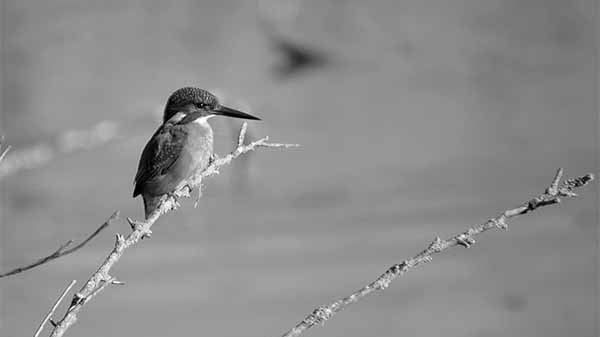
A kilometer or so from our start point, the walls end and there’s a big bloom of bougainvillea as the canal empties out into the Maha Oya, a few hundred metres from its sandy sea mouth. There’s a boutique hotel right where the canal hits the oya and a highrise is building where oya meets ocean. Breakers roll in beyond the river mouth. As we approach the beach, we see some of those Negombo-ish catamarans out sailing the sunlit swells. We cross to the oya’s north bank, there to enter a further stretch of the Hamilton waterway. What a different world this is! No canal walls, lush vegetation right down to the water edges: we are in the Gin Oya, which loops generally northward for several kilometers, one of the natural watercourses Mr. Hamilton managed to utilize on his way toward Puttalam. It’s lovely here. The oya twists, turns, curls and splits into branches, some of them intriguingly narrow and overgrown, requiring a canoe to navigate. After a while we pass an opening out to the sea, with a beach that looks deserted and desolate. We see kingfishers aplenty—pied and white-throated, along with so-called ‘common’ kingfishers, which our guide assures us are quite rare! In the shallows where we can peer through a space in the mangroves to the muddy water’s edge, a purple heron pads softly, freezes, then swiftly plunges her whole head into the water, coming up with a wiggly hand-size fish in her lengthy beak. I’ve never seen so many water monitors in such a short span of time. Here’s a good-size one looking like she just ate, lumbering at the edge of the mangroves; here a baby perched for safety on a tree branch out over the water, higher than our heads; there’s one napping, half hidden by underbrush on a steep embankment; this cheeky juvenile here is swimming right up to check out our boat!
We are not in the middle of nowhere. Power lines and various bridges span the water, some so low you feel like ducking. Appealing little hotels and eateries appear here and there. We see the tall chimneys of several tile factories, some of which have an abandoned feel about them. I hear a splash behind to our right and see that a gentlemen atop a cement stoop has just thrown his black lab into the water for a bath. A little further on we sidle near the bank to sidestep a decrepit fishing skein strung across the channel. We stop to feel and examine some soft and flexible mangrove shoots that can be harvested to make bottling cork. We pass under the main Negombo-Chilaw road and soon afterward arrive at our turn-back point: a 15-foot-high sluice gate blocking further navigation. It protects against downstream flooding from heavy upstream rain. It is curious to learn that travel from Negombo to Puttalam by inland waterway is impossible today: you could not do it even in a kayak. Just south of Marawila, Gin Oya wanders off to the east, never to resume its northerly trajectory. From there it is dry land or at best wet paddy for several kilometers northwards to the next navigable waters, back from the beach at Hotel Club Palm Bay. You could paddle some way north from there in Annankalliya Lagoon but you would soon hit another dead end of water. At that point, you could drag the kayak across paddy for a couple hundred metres and plunk down in a short patch of walled canal leading north to meet Karambalan Oya. Long story short: only from there could you proceed to Puttalam entirely by inland waterway, crossing Chilaw and Mundal Lagoons and otherwise threading through stretches of both walled and un-walled watercourses. Research so far reveals no explanation for the ‘Marawila gap’ in the Negombo-Puttalam waterway. Perhaps the canal was never completed across that stretch or perhaps the sea has encroached and swallowed the inland channel behind an eastwardly migrating shoreline.
FUTURE
With their role in transport gone, the canals merge in significance back into what they drain and flow through. What the Company may have viewed as waste land we now begin to understand as wetland. Much of that wetland is now city of course, prone to disruptive flooding by its location and climate. By channelling and accelerating runoff, the canals help alleviate inundation. Properly reconfigured, the canal system could do even better in that regard. Authorities are working on it. But the unpaved remaining wetland merits careful consideration as well.
Biologists concur that wetland is among the most fertile habitat types on our planet. They highlight ‘ecosystem services’ such as the Colombo wetland provides. Rice is grown, fish are taken, buffalo are grazed, traditional medicines are gathered. Evaporation from surface water and plant metabolism lifts heat into the sky, providing natural air conditioning for ground dwellers. Spongy mud cleanses water by absorbing pollutants. Lush vegetation metabolizes air pollutants, rendering them less toxic, as well as carbon dioxide, thereby mitigating climate change. Our wetland harbors many dozens of bird species and charismatic large animals: both mugger and saltwater crocodiles, Eurasian otters no less, and endangered nocturnal fishing cats.
The wetland is shrinking by more than one percent a year due to infill and solid waste dumping. It is hard to imagine reversing this trend unless many more people start getting out to see it. The canals are pathways into it. The waterways of Rajagiriya and Kotte are especially nice to be out on. (I have paddled them by kayak, but not since seeing a 15 foot croc sunning itself on a Parliament Lake island.) Good news came during 2018: Colombo’s selection as a world ‘wetland city,’ one of the first 18 cities to be so designated under an international treaty. The designation entails responsibility to study and conserve the wetland. Dr. Priyanie Amerasinghe, with the International Water Management Institute, helped prepare the application. She is now working on a plan to form community committees that will monitor conditions on the canals and report on them via an app. She believes the canals can be promoted for ecotourism.
Urban Colombo is not terribly rich in tourist attractions. Despite the opening of multiple arcades, it is hard to imagine Colombo as a shopping destination like Singapore and Kuala Lumpur any time soon. Meanwhile, though we hear of using the canals very charmingly for commuter traffic, this may not be their viable future because the city is just too tightly organized around motor vehicles and roadways. So the most meaningful future for the canals may be the wetland itself. If tourists may not prolong their Colombo stopovers for shopping, maybe they would do so for something more unique, akin to our excursion through the Gin Oya. Bringing ecotourism and other recreation to the canals, through careful planning and branding, could boost the local economy while helping preserve our wetland habitat. That’s precisely what the Dutch are doing with their homeland canals these days.