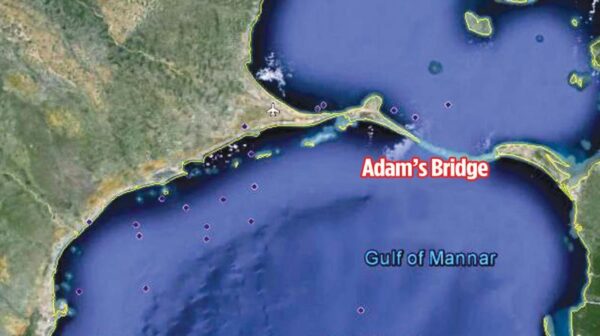
Adam’s Bridge – indicating a primordial bond – By Arundathie Abeysinghe A chain of pale gold limestone shoals that stretch between *Mannar Island, off the Northwestern coast of Sri Lanka and Rameswaram, off the Southeastern coast of Tamil Nadu indicate an ancient connection between Sri Lanka and India by land. According to chronicles, during the British Colonial Era, the British had named this chain of limestone shoals as “Adam’s Bridge” after the theistic legend regarding *Adam, the first man on the Earth. The British were of the view that Adam had used this bridge to reach *Adam’s Peak. The Bridge is also known as “Rama’s Bridge” or “Ram Setu”.   The Indian epic *Ramayana has also described a bridge over the ocean connecting India with Sri Lanka. According to the epic the credit of constructing the Bridge is attributed to the ape army that was assisting *Rama in his war ...

Read More →

Stories Behind Names of Places in Sri Lanka: GALEWELA – By Dr. Nimal Sedera Source :  Sri Lankan Group of Radio 4EB is pleased to present its Newsletter “Dæhæna” for August 2022. I trust you are enjoying the article series I am writing to Dehena continuously for the last four year or more. I enjoy writing this series as it is so much fun to know the history of our country. Galewela is in the Central province, in the Matale District, and the Trincomalee A6 road cuts across Galewela. It is 141 Km away from Colombo. It is a well developed area with a population of over 70,000 people as per the last census of the country. Mostly Sinhala Budddhist people live here with a growing Muslim community of over 10,000. King Kashyapa not only built Sigiriya he developed the land around the rock palace. His supervision would have been ...

Read More →

Balana Fort – strategic rock fortress in Kandyan hills By Arundathie Abeysinghe   Situated between *Kadugannawa Pass and *Alagalla Mountain Range, Balana Fort was constructed during the *Kandyan Kingdom as a strategic rock fortress and an outpost for the Kingdom. The mountain of Balana is located over 600 meters above sea level. At present, Balana is administered by the *Central Province and is also the boundary line between the *Sabaragamuwa and Central Provinces. Balana Fort (Balana meaning Look-Out in Sinhala) was utilized as a sentry point on the approach to Kandy and was a strategic defense post to prevent enemy invasions and the remains of the Fort can still be found on the summit. According to historians, the path behind the Balana Railway Station has been the old road which is a steep 2.5 kilometer climb to the summit of the mountain and extends comparatively flat to the open plains ...

Read More →

Gregory Lake – spectacular tourist attraction in ‘Little England’ By Arundathie Abeysinghe   Surrounded by spectacular vistas, breathtaking misty mountains and serene blue skies, Gregory Lake also known as Lake Gregory is a well-known tourist attraction as well as a location for recreational activities and water sports that has been in existence in *Nuwara Eliya from the British Colonial Era to date. Gregory Lake is the most prominent, scenic attraction and historical landmark in Nuwara Eliya town visited by local as well as foreign tourists. The Lake and its surroundings are crowded during April, the tourist season in Nuwara Eliya, although, some people, especially locals visit the area during the off season too. During the British Colonial Era, the Lake had been created with the objective of providing electricity to Nuwara Eliya town. To date, electricity to Nuwara Eliya town is generated from the water of the Lake. Yet, from ...

Read More →

Lakegala Mountain – wrapped in mystery and legend By Arundathie Abeysinghe   Located about 324 meters above sea level, Lakegala Mountain is a 1310 meter high rock famous due to its unique triangular pyramidal shape and colossal size. Spectacular Lakegala Mountain is one of the highest bare rock outcrops in the world. Meaning “Rock of Lanka” (Lankagala in Sinhala which later became Lakegala), Lakegala is situated about 175 kilometers away from Colombo in *Meemure. As Lakegala Mountain is situated in Meemure, the mountain is pristine and undisturbed from the external world and has abundant endemic flora and fauna. Situated in close proximity to Kandy and Matale Districts, there are several access roads to Lakegala. According to foreign tourists, the unique triangular shape of Lakegala Mountain resembles the “Matterhorn of the Rockies”.  The trek to the peak is arduous for average hikers, especially the last 300 meters of the journey. Hence, ...

Read More →

Meemure – Paradise hamlet in Central Highlands By Arundathie Abeysinghe   Located about 324 meters above sea level among verdant vistas, cascading waterfalls, terraced paddy fields, misty spectacular mountains, Meemure is an isolated paradise hamlet in the *Central Province with a population of about 400 people, away from modern day civilization. With exceptional natural beauty, magnificent fragrant wild flowers, arecanut (Areca catechu) and kithul trees (Caryota urens), reed bushes and cattle grazing in home gardens, eco friendly houses made of clay and spear grass, boundaries of houses as well as lands demarcated by stone-ridges with stones piled neatly, wooden fences leading to large home-gardens with rock stones as steps to reach the houses, this highland hamlet is a serene paradise nestled among breathtaking mountains. One boundary of Meemure is marked by the gently flowing Karambaganga Ela (Ela meaning stream in Sinhala). The hamlet is encompassed by scenic pyramid shaped *Lakegala ...

Read More →