Adam’s Bridge – indicating a primordial bond – By Arundathie Abeysinghe
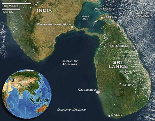
 A chain of pale gold limestone shoals that stretch between *Mannar Island, off the Northwestern coast of Sri Lanka and Rameswaram, off the Southeastern coast of Tamil Nadu indicate an ancient connection between Sri Lanka and India by land.
According to chronicles, during the British Colonial Era, the British had named this chain of limestone shoals as “Adam’s Bridge” after the theistic legend regarding *Adam, the first man on the Earth. The British were of the view that Adam had used this bridge to reach *Adam’s Peak. The Bridge is also known as “Rama’s Bridge” or “Ram Setu”.
The Indian epic *Ramayana has also described a bridge over the ocean connecting India with Sri Lanka. According to the epic the credit of constructing the Bridge is attributed to the ape army that was assisting *Rama in his war against demon king *Rawana to save *Sita. According to folklore, the Bridge was constructed by Rawana utilizing “floating rocks” that are made of weightless corals. Hence, the Bridge was a collapsible structure made to cross the sea to reach India, when necessary.
Adam’s Bridge is 30 kilometers long and separates the *Gulf of Mannar from the *Palk Strait. According to folklore, the surrounding sea is believed to be very shallow ranging from three feet to 30 feet deep (approximately 1-9 meters), depending on the location with sandbanks changing shape and shifting with the tide. Hence, the ride to the sandbanks takes approximately 45 minutes. It is a long stretch of sand protruding out into the water. The color of the sand in the location is different compared to other locations in Sri Lanka as it is a rare shade of black and pale gold with intricate designs similar to a pattern made from the waves constantly lapping at the shore. Yet, the vicinity is covered with tall grass and colorful plants.
Sandbanks in the location are no larger than a small playground and each sandbank could be encircled in approximately 15 minutes. There are 16 sandbanks out of which eight belong to Sri Lanka and eight to India. According to many visitors at the location, on a very clear day the Indian flag on the last of the Indian sandbanks of the Adam’s Bridge too can be spotted.
According to folklore, this bridge was constructed by an army of apes (forest-dwelling men often characterized as apes) to help Rama cross the ocean to rescue Sita. In another folklore, this was a bridge utilized by Adam during his journey between Sri Lanka and India.
Scholars are of the view that the Bridge is the remains of a land connection between the two countries, a result of them splitting apart, whereas some scholars are of the view that this is a buildup of sediment, coral and sand over several thousands of years.
According to scholars, in 1480, a cyclone apparently deepened the channels between India and Sri Lanka leading to the present condition. Nevertheless, some sections are only between 1 and 10 meters (3 and 30 feet deep), even at present.
The landscape at the location is surreal with views of the ocean as far as the eye can see…
In the past, visitors could go on boat rides around the shoals that make up the bridge, organized by either the Navy or local fishermen. Yet, these boat rides have been stopped due to recent incidents of human smuggling.
Route to Adam’s Bridge:
Travel up to Talaimannar Police Station. From this location onwards, it is necessary to seek permission from the security at Vayu Kitesurfing Resort and also to park the vehicle to visit the Bridge.
During high season, May to September, visitors can have a meal at “Vayu” and subsequently access the Bridge. Yet, during off season, this resort is closed.
There are also several routes used by fishermen in adjacent villages.
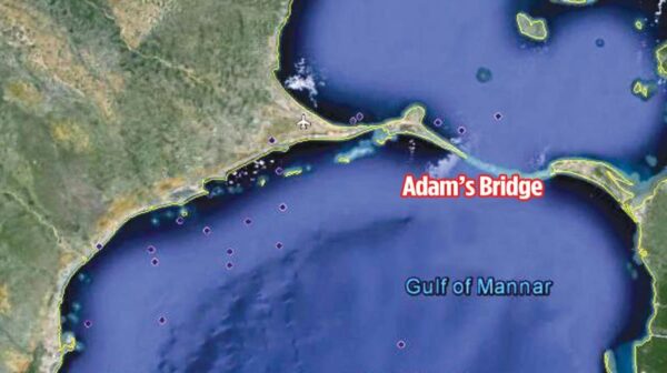
Image courtesy – brilliantmaps.com & deccanchronicle.com
- Adam – This is the name given in Genesis 1-5 to the first human. Beyond its use as the name of the first man, “Adam” is also used in the Bible. According to Judeo-Christian religions, Adam and Eve were the first humans and other humans have descended from them.
- Adam’s Peak – A 2,243 meter (7,359 feet) high conical mountain located in central Sri Lanka. Located in the southern reaches of the Central Highlands in the *Ratnapura District of the *Sabaragamuwa Province and Nuwara Eliya District of Central Province located approximately 40 kilometers (25 miles) northeast of Ratnapura and 32 kilometers (20 miles) southwest of *Hatton, the surrounding region is mostly forested hills and there is no mountain of comparable size nearby. The region along Adam’s Peak is a wildlife reserve including many endemic species.
- Central Province – The central mountainous terrain of Sri Lanka encompassing Kandy, Nuwara Eliya and Matale Districts and one of the nine provinces of Sri Lanka.
- Gulf of Mannar – An inlet of the Indian Ocean located between southeastern India and western Sri Lanka bounded to the northeast by Rameswaram (island), Adam’s (Rama’s) Bridge (a chain of shoals) and Mannar Island. The gulf is 130–275 kilometers (80–170 miles) wide and 160 kilometers (100 miles) long. Gulf of Mannar is well-known for its unique biological wealth and is a store house of marine diversity of global significance.
- Hatton – A small town tucked away in the central hills and has a cool moderate climate. Located in the Nuwara Eliya District of Central Province, Sri Lanka, it is a major center of the Sri Lankan tea industry
- Mannar – Situated in the Northern Province of Sri Lanka, Mannar consists of an area which is part of the mainland as well as Mannar Island, the largest islet in the country. Situated in the Dry Zone of Sri Lanka, the landscape of Mannar is varied; wooded jungles to paddy fields and palm trees. According to legends, Mannar Island had served as a connection to the southern tip of India in the past.
- Palk Strait – An inlet of the Bay of Bengal between southeastern India and northern Sri Lanka, a strait between Tamil Nadu state of India and Jaffna District of the Northern Province of Sri Lanka.
- Ramayana – This is an ancient Indian epic composed in 500 BCE to 100 BCE by Indian sage Valmiki. This epic composed in Sanskrit describes the conquest of Sri Lanka in 3000 BC by Prince Rama (Prince of Ayodhya, the eldest and favorite son of King Dasaratha, King of Ayodhya. Rama is an incarnation of God Vishnu) who fought with demon King Rawana (legendary emperor of Sri Lanka) to rescue his wife, Princess Sita.
- Ratnapura District – A major town in Sri Lanka and the capital of Sabaragamuwa Province. Ratnapura is the traditional center for gem trade.
- Sabaragamuwa Province – One of the nine provinces of Sri Lanka located in the south-central region of Sri Lanka.
Baobab Tree – iconic landmark in Mannar By Arundathie Abeysinghe
https://www.elanka.com.au/baobab-tree-iconic-landmark-in-mannar-by-arundathie-abeysinghe/
Kunchikulam Suspension Bridge – rare structure in the wilderness By Arundathie Abeysinghe