Golumale – unique geological formation – By Arundathie Abeysinghe
 Located in Meegolla in Yatamedura approximately 23 kilometers from *Walapane in the Nuwara Elya District, Golumale is a breathtaking hamlet bordering *Victoria, *Randenigala and *Rantembe Sanctuaries as well as the boarder of Central and Uva Provinces. One side of the hamlet borders a thick forest, whereas the other side has paddy fields, a unique breathtaking scene.
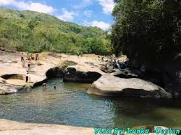
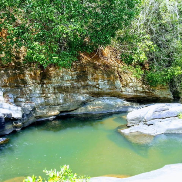
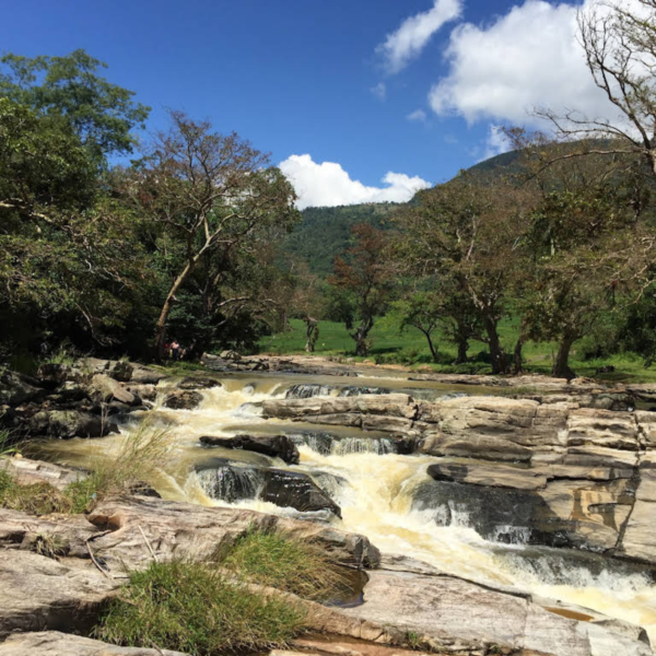
Golumale is a unique geological formation with a series of rock pools on the banks of a river created by years of erosion. There are also natural rock carvings and rock formations of various shapes and sizes at the location.
Golumale is considered as a wonderland due to its picture post card scenes, surrounded by splendid evergreen vegetation and a wildlife sanctuary one side of the river there is dotted with tree-houses that are constructed along this human and wildlife interface to enable the locals to keep an eye on their crops during day as well as night as elephants roam freely in the Randenigala forest reserve. The fence along the river bank assists to control elephants in the sanctuary. The location is considered as and it is one of the safest places for tourists to view elephants in their natural habitat, especially during late evening.
Situated off the beaten track, Golumale Rock Pools is an awe-inspiring location similar to a picture postcard scene due to a large rock pool with a couple of holes in it, through which water from the river passes at one end and emerges from the other side, a feature that can be seen when the water level is reasonably low as it is submerged in the river bed when the water level is high. Golumale River is formed by a tributary of the *Uma Oya.
As the dusk approaches, it is advisable to get into a tree house as wild elephants roam the rock, although it is not a daily occurrence. Adventurous tourists, prefer to sleep in one of the tree-houses. Villagers are hospitable and welcome tourists and some provide tea or meals to guests during a visit to Golumale.
Golumale is also known as “Disappearing River” by locals as the water completely disappears after flowing in to one of the largest cavities and further down the river this water joins the river through a smaller cavity. When there is a huge water flow, the water shoots out of this cavity and there are large rocks (that have been shot out) collected at the bottom.
According to locals, there are ruins of a palace in close proximity to this area hidden in the forest. According to legends, King Walagamba had two palaces in this area. The palace in the upper area has been known has “Uda Maligaya” and the palace in the lower area has been known as “Yati Maligaya”. These two areas have gradually evolved to “Uda Maligaya” as “Uda Medura” or “Udamedura” and “Yati Maligaya” as “Yati Madura” or “Yatimedura”. Villagers are of the view that the ruins in the location are those of “Yati Medura”.
Golumale is a popular bathing spot among travelers.
Image courtesy – golumale.stream.business.site & facebook.com
Directions: Travel along Udupusellawa road from Walapane and travel up to Dambagolla junction situated 11 kilometers from Walapane. From Dambagolla travel along Madulla thorugh picturesque hamlets, forests and paddy fields. Golumale is located approximately three kilometers along this road. There is a small handwritten board as “Golumale”. From this location, it is necessary to travel across a paddy field. At the edge of the paddy field and the river, there is an electric fence to stop wild elephants entering the village from Victoria, Randenigala and Rantambe Sanctuaries It is necessary to creep through this fence to reach the river.
Special remarks:
If camping at night in this location, it is necessary to stay in a tee house as elephants roam freely in the Randenigala forest reserve.
Nil Garunda Rock – unique rock deposit – By Arundathie Abeysinghe
https://www.elanka.com.au/nil-garunda-rock-unique-rock-deposit-by-arundathie-abeysinghe/
- Anuradhapura Period – This was a period in the history of Sri Lanka from 377 BC -1017 AD when the Anuradhapura Kingdom was established as the first kingdom in ancient Sri Lanka. King Pandukabaya (474 BC – 367 BC) was the first monarch to rule Sri Lanka from Anuradhapura from 377 BC. Buddhism played a major role during the Anuradhapura Period.
- King Walagamba (103 BC and c. 89–77 BC) – Also known as “Wattagamani Abhaya” and “Walagambahu” was a king of the *Anuradhapura Kingdom of Sri Lanka. Five months after assuming the throne, he was overthrown by a rebellion and an invasion from South India and he had to go into exile, yet 14 years later, he regained the throne by defeating the invaders.
- Mahaweli River – Sri Lanka’s longest river, 335 kilometers in length with a drainage basin of 10,448km2.
- Randenigala Dam – This hydroelectric dam is one of the largest reservoirs fed by the Mahaweli River opened in 1986 with height of 94 meters and 485 meters in length. It is an amazing structure and the surface area of the reservoir is 1,350 hectares. The picturesque reservoir is bordered on its northern shores by a National Park.
- Rantembe Dam – Located approximately 2.8 kilometers downstream of Randenigala Dam, Rantembe Dam is a 52-megawatt hydroelectric gravity dam at Rantembe, in the Central Province of Sri Lanka. Rantembe dam and power station form the most downstream project of a cascade of reservoirs and hydro power stations in Mahaweli River.
- Uma Oya – This is a Hydropower Complex also known as Uma Oya Multipurpose Development Project (UOMDP), an irrigation and hydroelectric complex in the Badulla District of Sri Lanka.
- Victoria Dam – The tallest dam in Sri Lanka, located on the *Mahaweli River and approximately 45 kilometers from Kandy.