Dawson’s Tower – accolade for exemplary service
By Arundathie Abeysinghe
 Anyone traveling from Colombo to Kandy on Colombo-Kandy Road has to travel through many bends, some of them hairpin bends and sharp gradients when traveling up the Kadugannawa Pass to reach Kandy. At the last and sharpest bend, the road forks and one road goes through a rock tunnel and the other road goes above the tunnel.
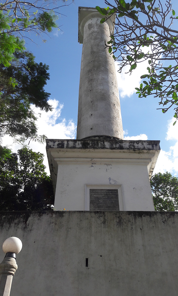
Before approaching Kadugannawa town, there is a tall while column to the right of the cliff which many consider as a war memorial. This enormous obelisk is a tribute to Captain William Francis Dawson, an imminent engineer of the Royal Engineers during the British Colonial Era who planned the construction of Colombo-Kandy Road under the direction of British Governor Edward Barnes (1824 – 1831). This huge white color obelisk similar to a lighthouse is 38 meters above the road and is a landmark on Colombo-Kandy Road which can be seen better when traveling from Kandy to Colombo.
After the end of Kandyan Rebellion in 1818, Governor Barnes was of the opinion that it was necessary to have a firm hold of Kandyan territory (former Kandyan Kingdom) and the necessity for a direct road to reach Kandy from Colombo.
Hence, in 1820s, during the British Colonial Era, Governor Barnes of the opinion that a new road should be constructed to reach Kandy from Colombo as the existing road to reach Kandy was long and circuitous via *Kelani River Valley to *Ruwanwella via*Ma Oya Valley along the incline to *Gampola to reach Kandy.
Construction of Colombo-Kandy Road commenced in 1820s under the direct supervision of Captain Dawson. The road up to Kadugannawa with sharp inclines, hairpin bends showcases Captain Dawson’s great engineering skills as he worked without bulldozers, backhoes as well as machinery which road constructors at present have access to. Hence, Captain Dawson’s construction of Colombo-Kandy Road demonstrates his expert engineering skills, a rare feat in 1820s, when modern sophisticated machinery was unheard of.
Captain Dawson studied the landscape of the territory marking the route stage by stage after analyzing the terrain and planned the construction of Colombo-Kandy Road. He planned the construction of Sri Lanka’s first highway constructed between two cities, Colombo to Kandy.
The stress and strain of working in a hot climate for several hours a day and frequent changes of climatic conditions which Captain Dawson was not used to led to his premature death on March 29, 1829 before the completion of Colombo-Kandy Road.
As Captain Dawson was a popular, highly regarded and respected person, his friends and admirers decided to erect a tower popularly known as “Dawson Tower” in 1832 as a tribute to his distinguished engineering skills, planning the construction of Colombo-Kandy Road bridging the Kadugannawa Pass.
According to legends, the location of Dawson Tower in close proximity to Kadugannawa Pass and Rock Tunnel were selected by Captain Dawson’s friends as a testimony to his technical expertise and engineering skills in planning the Colombo-Kandy Road, especially the hairpin bends and sharp gradients of the Road.
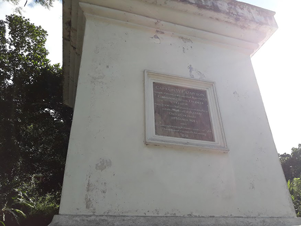
A plaque at the base of Dawson Tower records as follows:
“Captain W.E. Dawson, whose science & skill planned & executed this Road and other works of public utility.”
For those who like to explore this tower, it is necessary to seek permission from the caretaker who has the key to enter the Tower. There are 112 wooden steps with each step less than 0.6 meters wide supported by a tall central column as well as the wall of the Tower. As the steps are narrow, climbing down from the tower is more difficult with one step at a time.
- Gampola – A town in Kandy District, Gampola was the capital of Sri Lanka during the reign of King Buwanekabahu I in the mid 14th
- Kelani River – One of the major rivers in Sri Lanka and is 145 kilometers long.
- Ma Oya – The watershed of Ma Oya (Oya meaning stream in Sinhala) flows through four districts: Kegalle, Kurunegala (capital city of North Western Province), Gampaha (situated north east of Colombo in the Western Province) and Puttlam (large town in Puttlam District of North Western Province) of Sri Lanka.
- Ruwanwella – A Divisional Secretariat of Kegalle District.