Kadadora Viharaya – spectacular vistas of drought – By Arundathie Abeysinghe
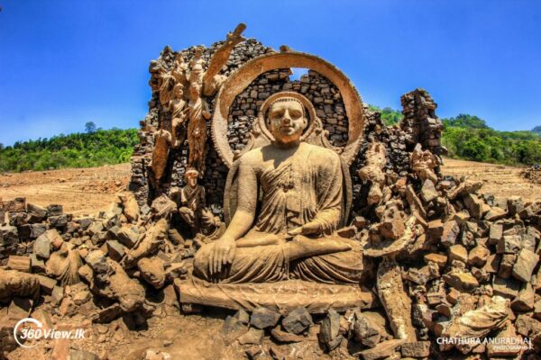
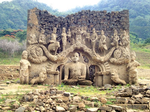
 Submerged by the water of *Kotmale Reservoir, spectacular ruins of Kadadora Viharaya, especially the sculptured statues of the Buddha and other deities that can be seen during drought is a rare surreal sight to behold …
Nestled in the breathtaking central highlands of Sri Lanka, engulfed by the misty cool climate, clear waters rippling in the gentle breeze blowing across the vast expanse of water, no one would believe that there are scenic attractions to feast one’s eyes on, beneath the tranquil waters…
Kadadora Viharaya in Kotmale is a nostalgic reminder of life in a bygone era…
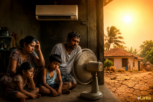
There are ruins of approximately 54 ancient temples of historic and archaeological value, 57 human settlements including villages, over 14 tea estates that were inundated with the completion of Kotmale Reservoir when the Reservoir was constructed damming Thispane and Kadadora hills in 1985. Many of these places do not exist, at present. According to sources from Mahaweli Authority, except for Kadadora Vihara, other shrines including Thispane Vihara, Othalawa Vihara, Morape Devalaya, Pattini Devalaya and Medagoda Vihara have been submerged when the reservoir was constructed and have no signs of existence, at present.
Villagers whose dwellings were submerged were relocated to adjacent hamlets before the construction of the Reservoir.
During the past decades, Kadadora Viharaya may have been visible only a few times. The Temple is mostly visible during March and April when the water is low and the villagers eagerly wait for these months to gather around the majestic remains of the Buddha Statue.
According to relocated villagers, they still visit their hometown to worship at the ruined temple, its statues and gather at the location and offer flowers and light oil lamps as done in the past.
During a drought, a large number of visitors flock to the reservoir bed of Kotmale Reservoir to see the half-visible temple and wander through the crumbling, yet magnificent temple with its antique architecture with nostalgic memories and photograph the temple and its surroundings…
According to locals, the Temple that existed before it was submerged by the water of Kotmale Reservoir was known as Kadadora Pratibimbarama Viharaya (Viharaya meaning temple in Sinhala) of Kadadora. The Temple, at present in ruins was first exposed around 2009 during a prolonged dry spell after it was submerged by water for over 30 years and was last exposed in early 2016.
Situated in Kadadora in Nuwara Eliya District, the Temple was abandoned and ruined when Kotmale Dam was constructed in 1979 by the Mahaweli Development program.
To compensate the loss of valuable religious site, Kadadora Viharaya, Mahaweli authorities constructed a dagoba (stupa) on the summit of the Kadadora Hill overlooking Kotmale Reservoir and named the stupa as “*Mahaweli Maha Seya” (which in height is second to Ruwanwelisaya in Anuradhapura), to symbolize the submerged religious monuments.
Image courtesy – ceylonpages.lk & 360View.lk
- Kotmale Mahaweli Maha Seya – The concept of constructing the stupa was initiated by former Mahaweli Development Minister late Gamini Dissanayake. The stupa was constructed to commemorate over 50 submerged temples. The height of the stupa is 88 meters (289 feet), the second largest stupa in Sri Lanka (largest stupa is Ruwanweli Maha Seya in Anuradhapura constructed in 140 BC). This stupa has also been constructed to compensate for the Buddhist temples that were inundated as well as a tribute to the villagers who sacrificed their ancestral land that had been cultivated for generations in the Kotmale Valley. The Stupa is constructed on the right bank hill above the location of the dam (Kotmale Reservoir) at an elevation of 950 meters (4150 feet).
- Kotmale Reservoir – The first project to be constructed under the Mahaweli Development Project. Kotmale Reservoir inundated more than 4000 hectares of fertile land including 600 hectares of paddy fields from late 1970s to early 1980s. Approximately 3400 families including 900 families from areas prone to earth slips were evacuated before Kotmale Reservoir and Dam were constructed.
- Kotmale – A significant historic location in the central highlands known as “Malaya Rata” (according to ancient Sri Lanka map) and the historically important region became the land of the Sinhala Kings and peasants. According to legends, villagers constructed the Kadadora Viharaya in the Kadadora village near Dehedukadulla on the banks of the Kotmale Oya (meaning stream in Sinhala), a tributary of *Mahaweli River.
- Mahaweli River – Also known as “Mahaweli Ganga” (in Sinhala meaning “Great Sandy River”) flows through tea and rubber-growing regions of Sri Lanka. It is the longest river in Sri Lanka, 335 kilometers in length with a drainage basin of 10,448km2.