Corbett’s Gap – amidst montane cloud forests – By Arundathie Abeysinghe
 Located along an abandoned jeep track along *Knuckles Conservation Forest, a designated UNESCO World Heritage, Corbett’s Gap is one of the highest mountainous passes in Sri Lanka named after British Army Colonel, naturalist, surveyor and adventurer, Jim Corbett who mapped the location. It is a montane cloud forest and home to a range of endemic flora and fauna, including several endangered species such as the purple-faced langur (also known as the purple-faced leaf monkey – Trachypithecus vetulus) and the Sri Lankan leopard (Panthera pardus kotiya). The terrain of the location rises to 3000 feet (approximately 915 meters), above sea level.
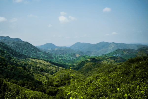
The trail to Corbett’s Gap offers breathtaking views of *Knuckles Mountain Range, verdant tea fields, a tiny hamlet almost similar to a picture postcard nestled in the foothills of the mountains that include isolated village communities. The trail provides a view of the charming panorama of the region, an awe-inspiriting view…
Towards the end of the trail, there is a lush mist laden cloud forest canopy with panoramic views of the surrounding mountain ranges…
Corbett’s Gap is a deep valley and the vegetation varies between dry evergreen forest and wet and dry patna grassland including montane vegetation. Most trekkers commence their trek from *Hunnasgiriya.
Considered as one of the most memorable and photographed locations, locals refer to Corbett’s Gap as “Attala-Wettuwa.” Corbett’s Gap has ideal conditions for hiking and trekking with a trail that has become popular among hikers.
Corbet’s Gap is reachable by any vehicle through Hunnasgiriya–*Meemure Road and from Hunnasgiriya junction, it is approximately 19 kilometers.
Distance: 10 kilometers hike
Duration: approximately 4.5 hours
- Hunnasgiriya Mountain Range – Located within Central Province. Hunnasigiriya is in the southern part of the Knuckles Mountain Range and one of the entering points to the Knuckles massif. It is a 1184 meters peak famous for amazing views. The lower slopes of the Mountain are covered by tea plantation and sub-montane forest.
- Knuckles Conservation Forest – Situated within Knuckles Mountain Range and located at an elevation of 640 -1676 meters (2100- 5500 feet), it is a World Heritage site and strict natural reserve. Knuckles Conservation Forest is a bio-diversity hotspot and habitat to numerous flora and fauna endemic to the region. Situated at an elevation between 2100 and 5500 feet (approximately 640 meters to 1675 meters), the vegetation at Knuckles Conservation Forest is diverse with pockets of cloud forest, dry evergreen forest and wet and dry patna grassland. There are steep slopes and ravines that give rise to numerous streams as well as small waterfalls with unique microcosms within small areas. The unpredictable weather of the location adds to its charm with thick mist enveloping the slopes within minutes.
- Knuckles Mountain Range – Located in Kandy and Matale Districts at a height of approximately 914 meters above sea level with a land area of around 21 hectares, Knuckles Mountain Range has a total of 35 peaks which rise above 900 meters. British Surveyors called this Mountain Range Knuckles Mountain Range as the Range is similar to a clenched fist.
- Meemure – Located approximately 324 meters above sea level among verdant vistas, cascading waterfalls, terraced paddy fields, misty spectacular mountains, Meemure is an isolated paradise hamlet in the Central Province with a population of about 400 people, away from modern day civilization.
Meemure – Paradise hamlet in Central Highlands – By Arundathie Abeysinghe – January 11, 2021
https://www.elanka.com.au/meemure-paradise-hamlet-in-central-highlands-by-arundathie-abeysinghe/