Mahakanadarawa Stone Bridge – skilled craftsmanship of yesteryear – By Arundathie Abeysinghe
 Centuries ago, Sri Lankans had well-planned infrastructure, irrigation systems including well-constructed tanks supplying water for agricultural purposes, architectural marvels such as cave temples, dagobas (stupas), well-designed palaces, meditation houses, audience halls and a superior road network as well as bridges…
During the early period of the Anuradhapura Kingdom, the main administrative centers were *Anuradhapura and Magama in *Ruhuna with a highway linking these two cities. A road network also connected Anuradhapura with Jambukolapattana (Dambakola Patuna) in the Jaffna Peninsula, Mathota or Mahatitta (also known as Manthai) near Mannar and *Trincomalee (known as Gokanna). These three ports served as the most significant trade centers. Anuradhapura-Dambakolapatuna Road was via the villages of Rambeva, Omanthai, Pavatkulam and Vavunikulam. There were several stone bridges including those in close proximity to Anuradhapura over the Malwathu Oya (“Oya” meaning stream in Sinhala) and another at Pavatkulam over the canal. Stone beams and slabs of these bridges still exist and some are still intact, although not utilized at present. The remains of the bridge at Periyapulankulama in Anuradhapura, popularly known as “Galpalama” (Stone Bridge) is a popular tourist site, although it is partially hidden in a forest.
The other popular stone bridges are the bridge over Halpan Ela in Anuradhapura, the bridge located in close proximity to Mahakanadarawa Reservoir in Mihintale, the bridge at Girihandu Seya in *Tiriyaya and Kayankerni Stone Bridge in the Eastern Province.
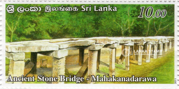
Among the stone bridges, the well-preserved stone bridge constructed over the Kanadarawa River, popularly known as “Mahakanadarawa Stone Bridge” located in the ancient road between Anuradhapura and Gokanna (Trincomalee) is a popular stone bridge, an indication of the technological skills of ancient Sri Lankans.
According to scholars, this bridge was part of the ancient road network that linked Anuradhapura to the north of Sri Lanka.
This bridge is believed to have been constructed during the same period Mahakanadarawa Wewa (Wewa meaning Lake) was constructed by King Mahasena (276-303 A.D.). Smoothed stone slabs longitudinally placed over cross beams balanced on stone columns are erected across the river. During the construction process, the water level of the river during floods has also been taken into account. According to the dimensions of the Bridge, it had been designed to serve vehicular traffic too.
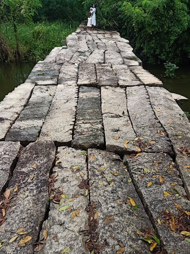
The existing structure of the Bridge at Mahakanadarawa is 80 feet (approximately 24 meters) in length and ten feet (approximately three meters) in width. Ten feet (approximately three meters) long 14 stone beams of the size of 16×12 inches (30×40 centimeters) have been paved across it. The Bridge is supported by 42 columns of 12×12 inches (30.48 x 30.48 centimeters) fixed on rocks on the bed of the river.
The well-constructed road network of the ancient city of Anuradhapura has been documented in the records of Chinese monk *Fa-Hsien who visited the island around 415 A.D. According to him, roads and streets in the city of Anuradhapura were excellently laid out and beautifully maintained.
Image courtesy – lankastamp.com & top-rated.online
- Anuradhapura – A major city in Sri Lanka (former Ceylon), the capital of Anuradhapura District. Anuradhapura was one of the ancient capitals of Sri Lanka and is famous for its well-preserved ruins of Sri Lankan civilization. Founded in the 4th century, Anuradhapura was the capital of Sri Lanka until the beginning of the 11th century. Anuradhapura is considered sacred to Buddhists and there are monasteries and stupas within an area of 40 square kilometers. Situated approximately 205 kilometers north of Colombo, Anuradhapura was declared as the “Sacred City of Anuradhapura” and a World Heritage Site by UNESCO in 1982.
- Fa-Hsien (337 CE – c. 422 CE) – Also referred to as Fa-Hien was a Chinese Buddhist monk and translator who commenced his arduous journey at the age of 60 from China to India to acquire Buddhist texts. He is considered as one of the earliest pilgrims to India. He visited India in early 5th century, initiated Sino-Indian relations and his writings give significant information about early Buddhism. During his journey, he visited sacred Buddhist sites in Central, South and Southeast Asia between 399 and 412 CE, of which 10 years were spent in India. He set out with nine others to locate sacred Buddhist texts and is said to have walked from China across the icy desert and rugged mountain passes. During his return journey, he has taken a large number of Sanskrit Buddhist texts and images sacred to Buddhism. Upon his return to China, he has translated these Sanskrit texts into Chinese which influenced East Asian Buddhism and the history of Chinese Buddhism that followed. During his journey from China to India, he has spent two years in Sri Lanka too.
- Ruhunu Kingdom – Also known as “Ruhunu Rata” (meaning Ruhunu country in Sinhala) is a region of present Southern, *Uva and Eastern Sri Lanka> It was also known as Kingdom of Ruhuna, the center of a thriving civilization.
- Tiriyaya – A small village in *Trincomalee District of Sri Lanka situated approximately 40 kilometers north of Trincomalee town.
- Trincomalee – Situated on one of the world’s natural and beautiful deep-water harbors, considered for millennia to be one of the finest in Asia. Trincomalee is a port city located on the northeastern coast of Sri Lanka. During Anuradhapura and Polonnaruwa periods, Trincomalee was used as a trading port and was the focus of battles during the colonial period when Europeans competed to control the island.
- Uva Province – This is the fourth largest province in Sri Lanka bordered by Central, Eastern and Southern provinces.